Lately, I had shared a quick tip of using a simply calculated field with just a country name in it to createa country field that you can use for example to beautify your map visuals.
Another use case is when your dataset does not allow you to edit it and only carries values that are ambiguous. Most often this is the case for US data. E.g. many cities or counties in the US are not exactly unique when you do not have the state as a secondary information to it.
On Tableau Desktop you can simply edit ambigious geo data by clicking on the info button on the lower right of your screen, select the country and the state.

Not so much on webedit, unfortunately.
But fear not, all you need to do is to create calcualted fields; dependin on your locale if it fits your country needs, there is no need to create a country field. If there is, create that as well.
So, for me, being in Germany, I create a field “USA” (with USA in it), right click it, set the geographic role to country and that’s it for this part.
Then, sticking with the upper example,create another calc named New York, add ‘New York’ in it. Set geo role to State/Province.

Finally, all you need to do is to create a hierarchy. Drag New York onto the USA field and drag your existing counties then onto New York.
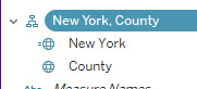
This way you have created a three-layer hierarchy that Tableau can interpret (Screen shows only two layers from another example).
And that’s it already for today.
A tiny yet maybe helpful tip for all webedit based developers.
Until next time.
Steffen

Leave a comment